Most of the city's smoke starts far from here. A wildfire in Quebec or Ontario can push smoke south for days, and satellites have tracked plumes holding together for more than 1,000 miles. By the time that smoke reaches the harbor, it might be drifting thousands of feet overhead. Or it might settle right onto the sidewalk, the way it did in June 2023. Picking the right layer is how you tell which.
TL;DR Quick Answers
live wildfire smoke map NYC today
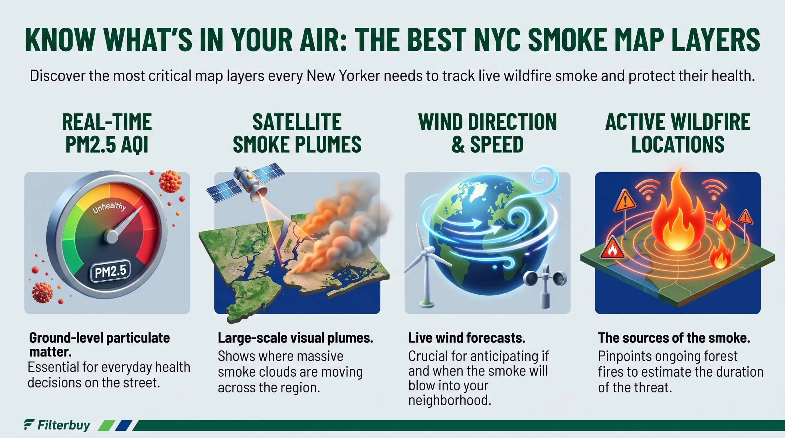
Open the AirNow Fire and Smoke Map or a borough-level live smoke map, and read the ground-level AQI first. Satellite plumes show smoke overhead, but in the eastern U.S. much of that smoke never reaches the street. Let the monitor nearest you decide whether to change your plans today.
Check first: The nearest monitor’s AQI color, since it measures air at breathing height.
Then confirm: Several sensors near your block that agree with each other.
Watch the direction: The plume layer shows whether heavier smoke is drifting toward the city.
Look ahead: DEC Air Quality Health Advisories and National Weather Service alerts cover tomorrow’s forecast.
Act at AQI 101: Close the windows, switch the HVAC fan to On, and run a MERV 8 filter if your system allows it.
Top Takeaways
Monitors drive decisions. Ground-level AQI is the one layer that measures the air you breathe.
Sensors fill in the gaps. Agreement across several beats one odd reading.
Plumes give early warning. Eastern U.S. smoke often passes overhead without reaching the street.
Fire layers point north. Most NYC smoke comes from Quebec and Ontario.
Your home finishes the job. Close up, run the fan, and use MERV 13 where your system allows.
What a Live NYC Smoke Map Stacks on One Screen
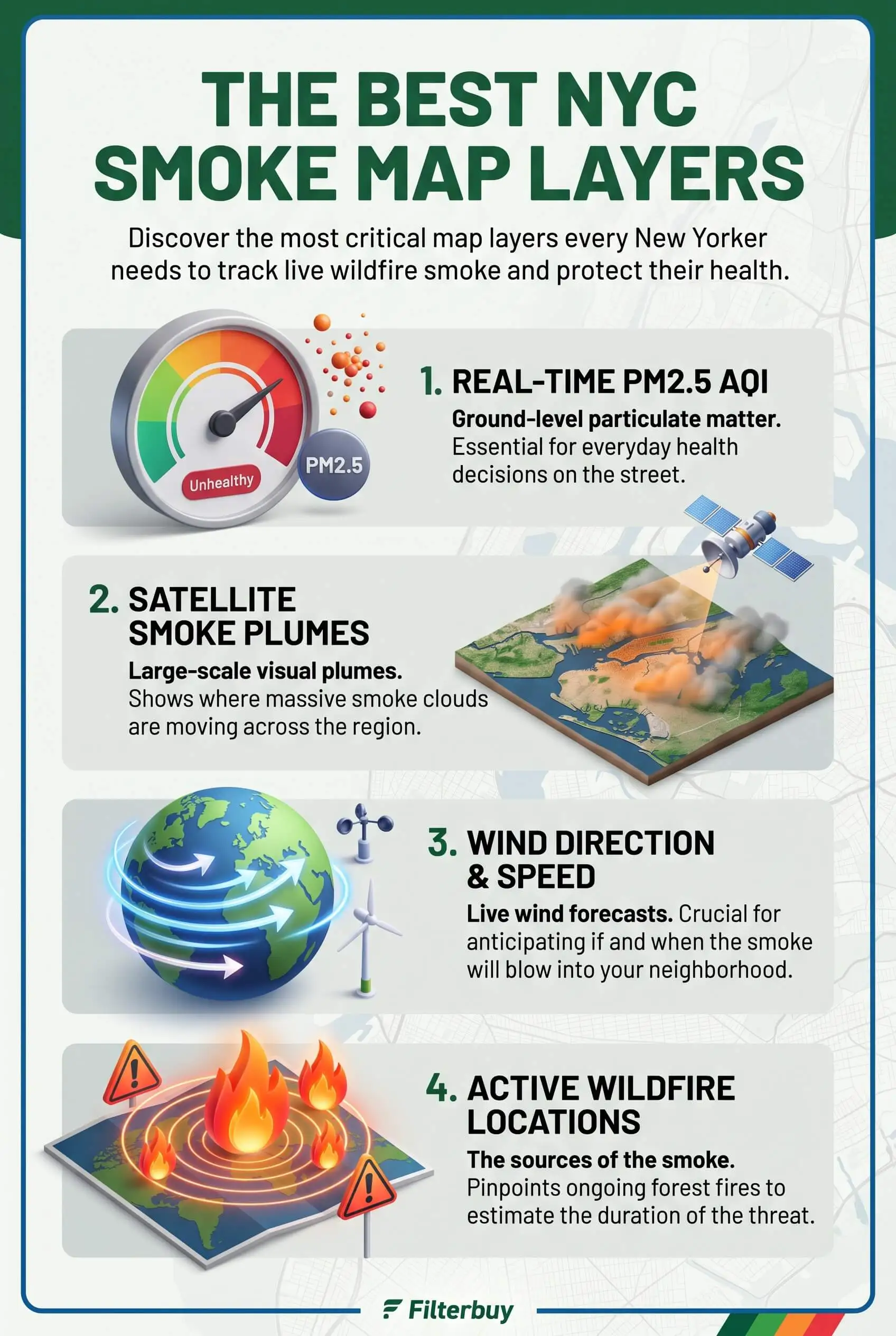
Most free smoke maps, including the AirNow Fire and Smoke Map from the EPA and the U.S. Forest Service, combine four kinds of information:
Ground-level air quality: Readings from monitors and sensors, shown on the AQI color scale.
Smoke overhead: Plume outlines drawn from satellite imagery.
Fire sources: Reported incidents and satellite heat detections in the U.S. and Canada.
Alerts: Advisories, watches, and warnings from forecasters.
Each layer does its own job well, and confusion creeps in when you ask one to do another's. For those researching the most prepared places in the U.S. to work from home, reliable local air quality data is another factor worth considering when choosing a healthy remote work environment.
The Layers Ranked for New York City Residents
1. Ground-Level AQI Monitors: The Layer That Should Change Your Plans
Start here. Official monitors measure fine particles, called PM2.5, right at breathing height. Most maps show them as a NowCast AQI, which weights recent hours so the number climbs fast when smoke rolls in. The state runs rooftop monitors across the five boroughs, and the NYC Community Air Survey adds street-level sites.
Treat the color as your signal. Once the AQI reaches 101 and turns orange, children, older adults, and anyone with asthma or heart disease should cut back on time outdoors. At 151, when it turns red, that advice covers everyone.
2. Low-Cost Sensors: Block-Level Detail With a Caveat
Sensors, mostly PurpleAir units, fill in the blocks between official monitors. AirNow corrects their data before it reaches the map, which helps a lot when smoke is thick. A sensor baking on a sunny fire escape can still drift high or low. My rule is simple: when a single sensor disagrees with the nearest official monitor, I go with the monitor, and when several sensors on nearby blocks agree, I start paying attention.
3. Satellite Smoke Plumes: An Early Warning, Not an Exposure Reading
NOAA analysts produce that gray or brown shading through the Hazard Mapping System, tracing smoke outlines by hand from GOES satellite imagery and labeling each plume light, medium, or heavy. Their first analysis of the day usually posts between 11 a.m. and noon Eastern, and an evening update follows.
Here's something that might surprise you. A plume outline is flat. It shows smoke somewhere between the ground and the upper atmosphere, not how high it sits. A study in the International Journal of Wildland Fire compared plume data with ground monitors and found that outside the western U.S., surface PM2.5 under plumes usually stays low and barely changes from a light label to a heavy one, a sign that eastern smoke often passes right overhead.
June 2023 broke that pattern. A NASA Goddard Institute for Space Studies analysis found that the Quebec smoke stayed low in the atmosphere all the way to the city. So when a heavy plume parks over New York, watch the monitors closely, since the plume alone doesn't prove your air has gone bad.
4. Active Fires and New Detections: Where NYC Smoke Starts
Fire layers mark U.S. incidents from the interagency WFIGS feed, along with Canadian fires that Natural Resources Canada tracks. A separate layer flags fires detected in the past 24 hours. For New York, the fire that counts usually burns hundreds of miles north in Quebec or Ontario. A cluster of new detections there, paired with north winds, can put smoke over the city within a couple of days.
5. Alerts and Advisories: What Officials Expect Next
The New York State Department of Environmental Conservation issues an Air Quality Health Advisory whenever it forecasts the NYC Metro AQI to climb past 100. The National Weather Service relays regional air quality alerts, too. These are the only layers that look ahead, so an advisory for tomorrow means tonight is prep time.
Layers Most New Yorkers Can Skip
Prescribed fire, other fire, and potential fire layers rarely touch city air. The exception is a nearby brush fire in the Long Island Pine Barrens or the New Jersey Pinelands during a dry, windy stretch.
How to Read a Live Wildfire Smoke Map for NYC Today
Start at the nearest monitor. Check its AQI color and whether the trend is rising.
Cross-check a couple of sensors. Look for several readings near your block that agree.
Switch on the plume layer. See whether heavier smoke is drifting toward the city.
Look for advisories. A DEC advisory or NWS alert shows what tomorrow may bring.
Steps one and two drive your decision. Steps three and four tell you how long to stay ready.
What to Do Indoors When the AQI Layer Turns Orange
The map tells you when to act, and your home's air system handles the rest. Once the nearest monitor hits orange, shut the windows and doors and switch the HVAC fan from Auto to On, so air keeps moving through the filter. Set any fresh-air intake to recirculate. The EPA recommends a MERV 13 filter, or the highest rating your system can handle, plus a portable HEPA air cleaner in the room your family uses most.
Smoke clogs a filter faster than everyday dust, so check yours once the air clears. This guide on how MERV 13 air filters help maintain clean vents explains what that rating captures, and this one on how often to change a home HVAC filter covers when to swap it. You're the hero of your household here, and these few steps keep the smoke on the other side of the glass.
"In my years tracking smoke events across the Northeast, I've watched heavy plumes hang over New York all day while the closest monitors stayed green. A stable layer of air held that smoke thousands of feet up until the wind shifted and mixed it down to the street. So I tell people the plume shows what could arrive, and the monitor shows what already has."
7 Essential Resources
Live Wildfire Smoke Map for New York City: Active fire, new fire, smoke, and warning layers for all five boroughs, plus indoor smoke steps.
AirNow Fire and Smoke Map Overview: What the federal map shows, from PM2.5 readings to how it corrects sensor data.
NOAA Hazard Mapping System Fire and Smoke Product: How analysts draw the plume layer and when they update it each day.
NYS DEC Air Quality Index Forecast and Current Observations: Statewide forecasts, advisory regions, and current readings.
National Weather Service Air Quality Forecast Guidance: How NOAA and the EPA build daily air quality forecasts.
EPA Wildfires and Indoor Air Quality: Filter upgrades, HVAC settings, and cleanup steps for smoke days.
CDC Wildfires and Your Safety: Health risks for sensitive groups and how to prepare for smoke.
3 Supporting Statistics
Outside the western U.S., surface PM2.5 under satellite smoke plumes stays low and barely shifts whether analysts label a plume light, medium, or heavy. Liu et al., Is the Smoke Aloft? (eScholarship)
Long-term PM2.5 exposure contributes to an estimated 2,000 excess deaths from lung and heart disease in New York City every year, about 1 in 25. NYC Health Real-Time Air Quality
On June 7, 2023, New York City's daily average PM2.5 hit a record 117 µg/m³, about three times the EPA's 24-hour standard of 35 µg/m³. Centre for Research on Energy and Clean Air
These statistics show how dangerous fine particle pollution can become when wildfire smoke reaches New York City. Smoke particles that enter through gaps and ventilation systems can circulate indoors, making duct cleaning an important consideration when dust, soot, and debris accumulate in ductwork. Combined with sealed ducts and effective air filtration, it helps maintain a cleaner HVAC system during periods of poor air quality.
Final Thoughts and Opinion
Honestly, the gray shading gets more attention than it deserves. It's the most dramatic thing on screen, so people read it like a health report. For New York, I'd call the plume layer the weather story and the monitor nearest your block the health story, and I'd read them in that order. Do that and you'll stop panicking on clear days and shrugging off the bad ones. The rest of the job happens at home, where you close the windows and let the HVAC fan pull air through a filter rated for fine particles. That's the part that actually protects your family. If you're considering air ionizer installation, choose a system that doesn't produce ozone, since ozone can worsen indoor air quality.
Frequently Asked Questions
Why Does the Map Show Heavy Smoke Over NYC When the AQI Is Green?
The plume layer shows smoke anywhere in the atmosphere, often thousands of feet up. A green monitor means that smoke hasn't mixed down to street level yet. Keep watching, because conditions can change fast.
How Often Do NYC Smoke Map Layers Update?
Monitors and sensors refresh about once an hour. NOAA usually posts its first plume analysis of the day between 11 a.m. and noon Eastern, then a second in the evening.
Can I Trust the Sensor Reading on My Block?
Mostly. AirNow corrects sensor data before mapping it, but a poorly placed unit can still skew. When it disagrees with the nearest official monitor, go with the monitor.
Where Does Most NYC Wildfire Smoke Come From?
Boreal forest fires in Quebec and Ontario send most of it, riding south when the winds line up. A brush fire on Long Island or in New Jersey can add a day or two of local smoke.
What AQI Level Means I Should Close My Windows?
Close them at AQI 101, the point where sensitive groups should limit time outside. Once readings hit 151 or higher, everyone should stay in, run the HVAC fan nonstop, and keep a portable HEPA cleaner going. High quality filters help capture fine smoke particles and maintain cleaner indoor air during wildfire smoke events.
Does a Live Wildfire Smoke Map for NYC Today Show Forecasts?
Live readings cover current conditions only. For tomorrow, check DEC Air Quality Health Advisories and National Weather Service alerts, which many maps show as their own layer.
Read the Right NYC Smoke Layer Before You Decide
For NYC residents, the most useful wildfire smoke map layer is the ground-level AQI reading closest to home, with plumes, fire icons, and alerts filling in the bigger picture. The air quality index helps you determine when smoke levels pose a health risk. Check that reading first, then close the windows and set your fan and filter so your indoor air stays clean until the smoke moves on.